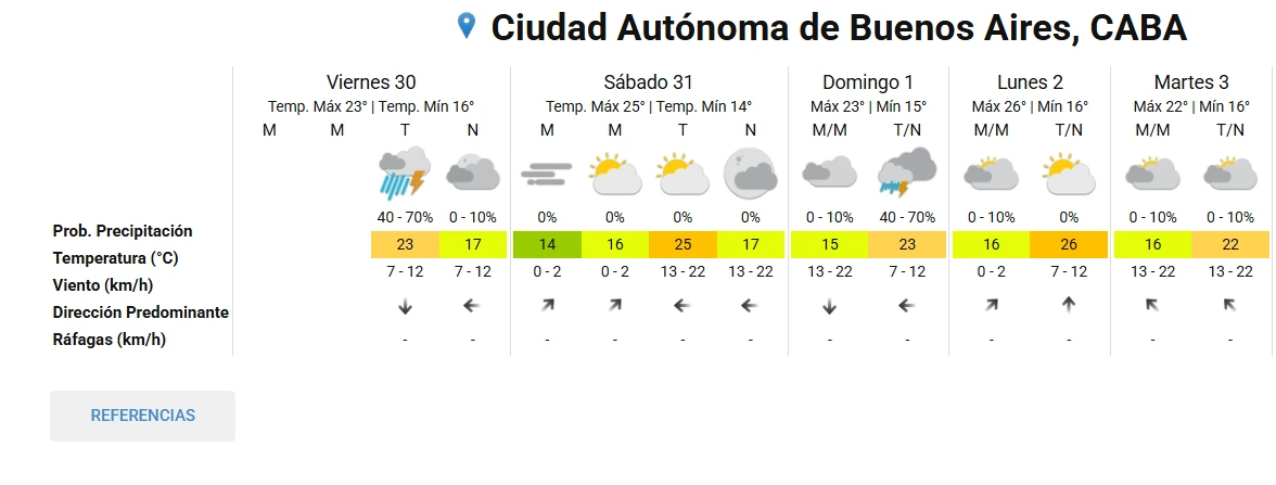
Bad weather has affected the City and the suburbs since early this Friday morning. Saturday brings relief, although the rains could return Sunday afternoon
Temperatures will range between a minimum of 14 degrees and a maximum of 25. It will be an ideal day to go out, run errands, or enjoy green spaces without the threat of downpours. The wind is not expected to be particularly strong, which adds thermal comfort during the afternoon.
This atmospheric respite comes just in time for those who had weekend plans postponed due to bad weather. However, it is wise not to let one's guard down completely: Sunday shows signs of instability again, although more confined to the latter part of the day.
Those planning outdoor activities on Saturday will be able to take advantage of the more favorable conditions. The Meteorological Service does not anticipate severe phenomena for that day, marking a clear contrast with Friday.
Sunday brings chances of rain again
Sunday, November 1, starts with a calm outlook. During the morning, the sky will remain mostly cloudy, and the chances of rain will be low, between 0 and 10 percent. The stability of the early hours will allow, in principle, to carry out activities without major inconveniences.
The change arrives in the afternoon and evening. According to the forecast, storms could return with a probability of precipitation that again falls between 40 and 70 percent. The maximum temperature will remain around 23 degrees, similar to Friday's.
The heavy storms that arrived in the early hours of this Friday are already being felt strongly throughout the Metropolitan Area of Buenos Aires. The National Meteorological Service confirmed that instability will persist throughout the morning and afternoon, with chances of rain ranging between 40 and 70 percent.
The maximum temperature for the day will be around 23 degrees, while the minimum will be close to 16. By nightfall, the outlook changes: the sky will remain mostly cloudy, but the chances of precipitation will noticeably decrease, between 0 and 10 percent. Thus, conditions will begin to stabilize by the end of the day.
This Friday's scenario requires taking precautions, especially for travel and outdoor activities. Rain may be intense at times and cause flooding in low-lying areas or those with drainage issues. Therefore, it is advisable to closely follow official warnings and avoid traveling through flood-prone areas.
The good news is that the frontal system causing this instability will lose strength as the hours go by. Nevertheless, the weekend will not be completely dry, and attention should be paid to what happens on Sunday.
How Saturday will be in the city and the suburbs
Saturday, October 31, is expected to be the most stable day of the period. No rain is expected at any time during the day, and the probability of precipitation is 0 percent. The sky will be partly cloudy, with periods of sunshine that will provide a respite after Friday's storms.